Sample report
What a parcel report actually says.
This is a real analysis of a real corner, built from Georgia DOT's own approved drawings and the county's own records. We produced it on our own initiative rather than at an owner's request, so that anyone can see exactly what the report contains before paying for one.
The site is a gas station at the corner of Johnson Ferry Road and Shallowford Road in Cobb County. It is losing about 570 square feet of frontage, and a new concrete median is removing every left turn that reaches it from Shallowford.
A concrete median is going in on Shallowford Road, and it changes how cars reach this gas station.
“The median will block left turns to or from Shallowford Road for the commercial driveways accessing the gas station to the south.”
Approved Concept Report, PI 0020001, page 5, approved February 14, 2025. The gas station to the south of Shallowford Road, west of Johnson Ferry Road, is this site.
What changes at the frontage
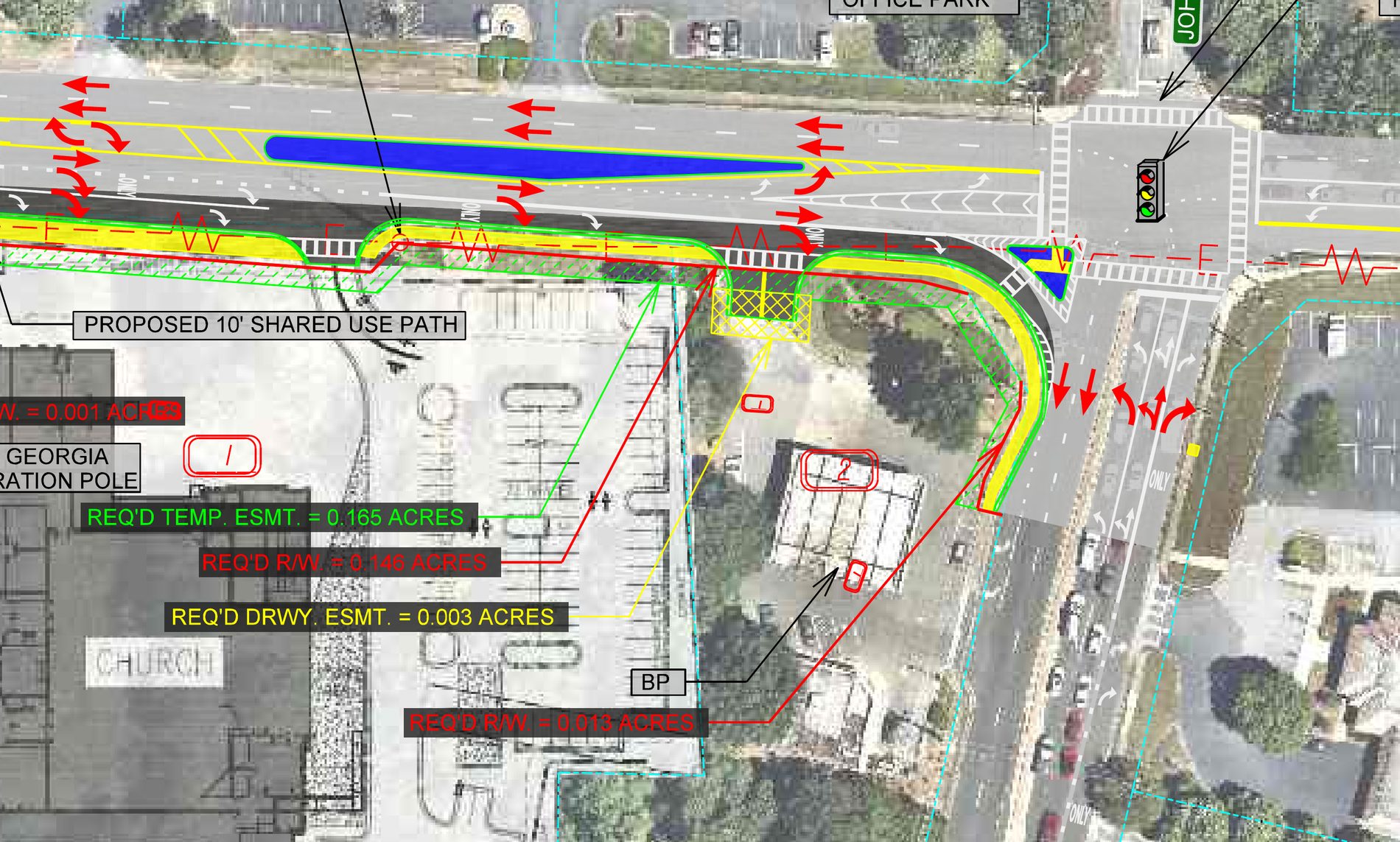
- Shallowford Road west of the intersection is widened by up to about 17 feet to carry a raised concrete median between the westbound through lanes and the eastbound through and left turn traffic. The median is up to 15 feet wide at its widest.
- That median blocks left turns into and out of the site's driveways from Shallowford Road. Vehicles approaching from the east can no longer turn across to reach it, and vehicles leaving can no longer turn left toward the intersection. The driveways become right-in and right-out from Shallowford.
- The eastbound approach to Johnson Ferry Road is rebuilt to three 11-foot lanes, left, through, and through-right, with the left turn storage at about 140 feet. The concrete island separating eastbound right turns from eastbound through traffic is rebuilt at roughly 450 square feet, together with the curb, gutter and a 5-foot sidewalk on this side of the road.
- The concept report states that this reconstruction terminates at the beginning of the full storage width of the right turn lane into the BP gas station, which is the south leg of this work.
- The strain pole and mast arm on the southwest corner are being reconstructed, which is this corner, to allow the new sidewalk to be built. Expect signal work directly at the frontage.
What is being acquired
The right of way cost for the whole project is estimated at $440,000 against $1,000,000 programmed, covering both parcels. The concept report records temporary easements on this corridor, not permanent ones.
What is being built, and why
Two dedicated westbound left turn lanes and two westbound through lanes, with one eastbound through lane removed east of the intersection and the west leg widened so the eastbound through movement lines up across the intersection. Signals are replaced at Johnson Ferry and Shallowford and modified at the Kroger driveway.
The stated reasons, from the concept report: Shallowford Road carried 26,500 vehicles a day in 2023, projected to 28,775 by 2029 and 34,975 by 2049, and Johnson Ferry 24,675 in 2023 rising to 32,750 by 2049. The intersection runs at level of service C in the morning peak and D in the evening, and is projected to fail, level of service F, in the 2049 evening peak even after this work. 181 crashes were recorded inside the project limits between January 2019 and December 2023, including 38 injury crashes and one fatality.
Dates, and who is doing it
How this site was identified in the drawings
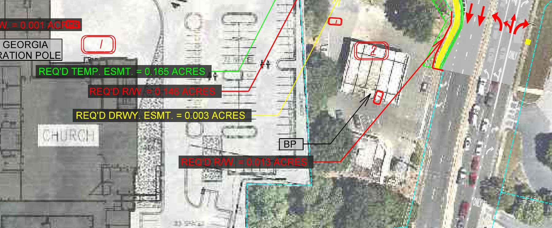
The concept display for the preferred alternative labels the corner property BP and numbers it parcel 2, carrying 0.013 acres of required right of way and a 0.003 acre driveway easement. That drawing prints no tax parcel number, so the match to 4324 Shallowford Road rests on three things that all agree: the concept report places a BP station 150 feet southwest of the intersection, the county record shows this parcel as 1.10 acres in commercial use at that corner, and the adjoining church property the drawing numbers parcel 1 is North Point Ministries at 4246 Shallowford Road, the next even address west. The document that would close it beyond inference is the right of way plan set, which assigns tract numbers to tax parcels, and it does not exist yet because the project is being delivered design-build.
What the documents do not settle
- When the acquisition starts. No right of way authorization date and no acquisition schedule is published for this project. Cobb County, not the state, will make the approach.
- Exactly where the new line falls on the lot. Because this is design-build, the construction plans that would carry stations and offsets at the frontage have not been produced. The 0.013 acres is the concept estimate, not a surveyed take.
- How far into the driveway the easement reaches. The drawing places the 0.003 acre driveway easement on this parcel, at the Shallowford Road entrance, just inside the property line it shares with the church. Its depth and its duration are set by the right of way plans, which do not exist yet.
- When construction begins. No letting or notice to proceed date appears in the approved documents.
What an owner can do with this
Two things are worth raising with Cobb County DOT at the number above, in writing, with the project numbers on it. First, asking to see the right of way plans for parcel 2 when they are produced, which is the drawing that will show the width of the take along the frontage. Second, asking how the median treatment at these driveways is detailed, since the concept report records that access restrictions drew comment at the public open house: of 45 formal respondents, 14 supported the project, 14 opposed it and 15 gave conditional support, with access restrictions named among the themes.
What this is based on
- Approved Concept Report, PI 0020001, approved February 14, 2025, including the Concept Display for the Preferred Alternative prepared by Kimley-Horn for Cobb County project B2437, the mainline design feature tables, the utility and property section, and the cost estimate summary.
- Approved Location and Design Report, PI 0020001, approved December 3, 2025, with the Notice of Location and Design Approval published under Georgia Code 22-2-109 and 32-3-5.
- Location and Design advertisement affidavit, on file January 2026.
- Cobb County parcel record for 16046700150, and the distance from this parcel to the published centerline, measured at 123 feet.
This describes what the approved Georgia DOT and Cobb County documents show as of their approval dates. It is not legal advice, it is not an appraisal, and it does not address an owner's or tenant's position under a lease, a fuel supply agreement or franchise documents, which govern separately. We do not predict what will be acquired; where this report states an area, it is the figure printed on the state's own drawing.
Reports like this one are $49. Finding out whether you need one is free.
Check your addressPrefer the original? Download this report as a PDF.